
New Site! Go To www.mocosnow.com!
We will no longer be using the weebly site. Go to www.mocosnow.com for all of the latest updates and follow us on twitter @MCPSsnow
Blizzard On Sunday???
I have gotten numerous e-mails about the possibility of a blizzard this weekend. While it's almost impossible to give accurate information this far out, I do not think the storm event coming on Sunday will give us anything close to a blizzard.
Right now, we don't even know if it will be a snow event (I hate cold rain). We will keep you updated, and we are hoping that things take a turn toward blizzard like conditions!
Right now, we don't even know if it will be a snow event (I hate cold rain). We will keep you updated, and we are hoping that things take a turn toward blizzard like conditions!
The Ice Storm Cometh (Midnight Update!)
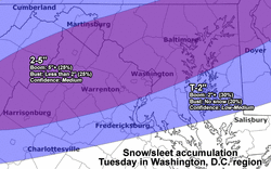
A Winter Storm Warning has been issued for MoCo starting at 7PM tonight until 10AM tomorrow morning. The timing couldn't be better for a delay or closing, however, the temperatures will be hovering around the freezing mark and need to be monitored closely.
As it stands, we can get about a half inch of ice with about an inch of slush on top of that. Ice closes schools. Ice also cuts out power, leaving us with nothing to do when we are not at school.
Let's hope for enough ice to keep us all out of school, as long as nobody loses power.
I think temperatures will definitley be above freezing by 7 or 8AM. Couple that with the fact that MCPS doesn't want to close schools, and i'm thinking definite delay at least.
Midnight Update: It just took me 3 minutes to walk from my car to my house (about 20 yards). The street and sidewalk was completely iced over. I'm thinking definite delay and probable school closing!
Midnight prediction: 3 Pencils

We Were Wrong :( (2/3/13)

Nobody hates being wrong more than I do, but I will openly admit that my prediction was off last night. Timing is everything with storms like these and the predicted 3AM-6AM change over to snow would have been ideal. Unfortunately, it's 7:30AM and most of MoCo is still a rainy mess.
I'm getting lots of questions about an early release, and while that possibility is still in play, it is unlikely. We still may get up to 4 inches of wet snow, though I see 1-2 inches as a much more realistic possibility.
Keep those fingers crossed for an early release...
I'm getting lots of questions about an early release, and while that possibility is still in play, it is unlikely. We still may get up to 4 inches of wet snow, though I see 1-2 inches as a much more realistic possibility.
Keep those fingers crossed for an early release...
Sunday Night Update (2/2 9:45PM)
As you can see in the map on the left (courtesy of Justin Berk), most of MoCo is in the 4-7 inch range. I am still leaning towards 3-4 inches, but this is definitely good news.
I am surprised this has not been upgraded to a Warning, but if things hold up...it still may.
The snow will begin between 3AM and 6AM, which is perfect timing for a school cancellation. Since we are "out of snow days," it will be a little harder for school to be cancelled than usual, but I will stick with my prediction.
Official Prediction: 3 Pencils!

Sunday Night/Monday Morning (2/2 & 2/3)
So there's a Winter Storm Watch for MoCo, and i'm sure it will eventually become a Warning. The National Weather Service says this storm has the potential to drop over 5 inches of snow! Unfortunately, the NWS often predicts high and drops their numbers down later on.
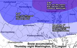
On Thursday, I was the FIRST to predict 2-4 inches of snow with this storm! Currently, I will stick to that prediction, but that number may go up if it gets cold enough. Remember, it will be almost 60 degrees on Sunday before we get cold and the rain turns to snow.
With all that being said, i'm gonna go ahead and predict that we will not have school on Monday. This prediction comes very early, and it can change...
Official Prediction: 3 Pencils

Craziest Week In Years!!!
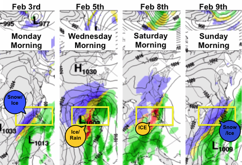
The photo on the left shows the possibility for one of the craziest weeks in years when it comes to winter storms (courtesy of Justin Berk).
We have the possibility of Snow and Ice on Monday morning. Enough that schools can close on Monday and Tuesday!
Then, on Wednesday, we have an ice/rain combo that could give us another day or two off...depending on how much ice we get, when it all turns to rain, and if it'll be cold enough to freeze the next night.
The Saturday into Sunday storm is very far off, but it would come right before a possible blizzard! It's hard to predict a storm that will hit in a few hours, let alone the following week...but we can be in for some serious snow days!
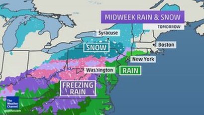
Crazy Storm Coming!
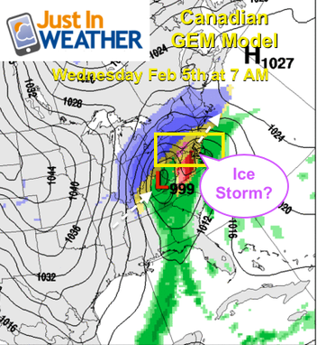
Based on meteorologist Justin Berk's photo on the left, we have a model showing the possibility of a HUGE ice storm for the middle of next week (looks like Wednesday for now).
We have to remember that winter forecasts for our area can change really quick, so nothing is definite.
As of now, i'm thinking we will see something late Tuesday into Wednesday morning. What will we see? Very hard to forecast something 5 days away, but I am going to be optimistic.
I am NOT a meteorologist, but looking at the different models...I can see 2-4 inches of snow with Mondays storm. Unfortunately, Wednesday is looking like more of a rain event for now...but that can easily change.
We also have a possible blizzard for the Sunday after this one, but that is so far out that there is absolutely no way to tell what is going to happen.
Stay tuned!
Will We Wake Up To Snow Tomorrow (Wednesday, 1/29) Morning? 4AM UPDATE!
This is one of those rare times that a snow storm will hit the south harder than it hits us. We may not even get anything.
The photo on the left, courtesy of Capital Weather Gang, shows a "bust" scenario of 1-3 inches, but there's only a 20% chance of that happening.
My official prediction, as of 2pm on Tuesday, is that we will have about half an inch of snow and a full day of school :(
4AM UPDATE! We got a little more than expected and the side streets are slick! 2 pencils!
Official Prediction: 2 Pencils

Friday Fact 1/24/14
I wanted to share with you some pretty cool facts about school closings and delays, but first I wanted to address a couple e-mails I got last night about the possibility of a delay for this morning (you can e-mail me and ask your qustion by clicking on the 'Contact Us' link at the top of the page).
My sources told me that there was no chance of a delay, so I didn't bother posting anything, but next time I will share that information with all of you as well :)
Did you know that in the last decade we only had a 2-hour delay (caused by 1 storm) on consecutive days only once.? We have had two 2-hour delays in a row because of different storms on several occasions, but only once because of the same storm. This morning wasn't any different. There's always a chance of melting and re-freezing, but it's very rare.
I hope that answers any questions you have about why there wasn't a delay today!
What About Thursday 1/23???
Its colddddd outside, and that's a huge part of why we stayed home today. It's gonna be cold all day today and the high tomorrow will only be 23.
People have been texting me all morning letting me know that their neighborhood streets are still in bad shape. I've gotten a few reports of school parking lots being untouched. I know the crews will be working hard to have everything ready for tomorrow, but I'm not quite sure they will be.
The bad news is that we are now officially "out" of built-in snow days. Any more snow days and they will have to be made up. Fairfax County lost a day off of school in February to make up for their extra snow day (they were off for the extreme cold a couple weeks back). MCPS will probably not have us make up the extra day at the end of the year because they don't have enough money to pay the teachers for the snow day and the extra day of work (Yes...teachers still get paid for snow days!). Unfortunately, I feel like they are more likely to give us a delay so that they don't have to worry about us going over the allotted snow days.
I don't have an official prediction yet, as it's too early to know anything for sure, but I will have one later on this evening...so keep checking! There is hope!
Wednesday 1/22
The snow is coming down hard! As of noon today, we're at 2.5 inches in the Kentlands/Rio area.
Most forecasts are predicting between 6-10 inches by the time it all stops around midnight tonight. It's gonna be COLD tonight, so I don't see side roads and sidewalks improving by the morning.
There's a really good chance we will have a FIVE day weekend.
Official Prediction: 4 Pencils!
Most forecasts are predicting between 6-10 inches by the time it all stops around midnight tonight. It's gonna be COLD tonight, so I don't see side roads and sidewalks improving by the morning.
There's a really good chance we will have a FIVE day weekend.
Official Prediction: 4 Pencils!

Biggest Snow Storm of the Year on Tuesday(1/21)???
The storm coming tomorrow, Tuesday 1/21, has the potential to be the biggest snow storm of the year!
Its early, but I've seen predictions anywhere from 2-4 inches all the way up to 5-8 inches. The National Weather Service is predicting 5+, but I don't usually trust them.
My prediction for this area, currently, is 4-6 inches of snow. The snow will start before noon on Tuesday and will end Tuesday evening. It will be cold, so I definitely see a delay or closing coming on Wednesday.
Check for updates!
Freezing Rain on Friday Morning (1/9)
Freezing Rain Advisory for us until 9AM tomorrow! The timing is perfect for a two hour delay, and that is what I expect!
Official Prediction: 2 Pencils!
Official Prediction: 2 Pencils!

YOUR Thoughts On The Decision To Open On Time (1/7/14 6:45AM)
Good morning everyone! A lot of you contacted me to weigh in on the decision to open schools on time. Here's what some of you had to say:
William Zheng said: If we can't go outside for PE when the wind chill is under 35 degrees how do you expect us to walk to school or the bus stops or anywhere when it feels like it is under 0 degrees? RIDICULOUS DECISION MCPS!
Harry Deutsch said: I have to walk very far for me to get to school and i am in fear of frost bite or perhaps dying, is there any chance MCPS will change there decision by % am
tomorrow if not I might not be able to go to school
tomorrow.
Carter Outsa said: I can see the arguments for both sides of the spectrum on this issue. Being a student, I personally support the idea of not having school, but here are the
facts. MCPS only gives 4 excused snow days during the year. We've already had 3,
before the end of the first semester. That makes times like this week, the final
exam review week, quite harder.
Gabriella Ospina said: It is TOO cold to be outside. Dumb STUPID
I was a little upset with this decision. Way too many kids have to be outside for way too long and it is very cold outside. With that being said...in my short time outside (walking from my car into the school...it wasn't as bad as I thought it would be. I still think we should've had the day off though.
BRRRRR!!! Too Cool For School? (1/6/14 5:20PM Update)
The high tomorrow will be under 15 degrees. We have forecasted wind chills as low as -20 degrees. That's 20 degrees BELOW zero.
I know that if 60% of classrooms in a Montgomery County Public School do not have heat, we will be out of school. That probably won't be the case for just about every school in the county.
Chicago schools have closed because of this cold front. Minnesota schools have closed because of this cold front (they neverrrrrr close due to cold).
Prince George's County Public Schools have announced a 2 hour delay.
DC Public Schools have announced they will open on time.
Will there be a delay? It'll be 2 degrees at 7AM and 4 degrees at 9AM...what would be the point of a delay?
In MCPS, elementary school students walk up to a mile to school. Middle school students walk up to 1.5 miles. High school students walk up to 2 miles! What about bus riders that have to wait at the bus stop???
Welp...looks like we will have a full day of school. Stay warm out there :(
If you want to share your opinion, click on the 'contact us' tab and I'll post a few later on today.
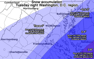
New Year, New Snow! 1/2/14 (9:30PM Update)
Earlier in the week there were talks that this storm could be a blizzard that brought us a foot of snow. Now, we'll be lucky to get an inch.
The map on the left has the entire county 1-2 inch zone with a 25% chance of more snow. and a 25% chance of less snow (photo courtesy of capital weather gang).
Our only hope is that the heavy bands of snow come after midnight instead of this afternoon. If that happens, we can see a 2 hour delay. If it doesn't, we'll be in school on time.
Official Prediction: 3 Pencils (please see the Rating System tab if you are unsure of what the pencils mean).

Re-Freeze on Wednesday Morning?
If anyone has been out this evening, you may have noticed that some of the snow that melted earlier has re-frozen, causing some slick spots on roads and sidewalks. Unfortunately, I don't think it will be enough to delay schools tomorrow. I would expect to be in on time.
Official Prediction: 1 Pencil
Official Prediction: 1 Pencil

TWO IN A ROW???
Let me start off by saying that I don't think we will get 5+ inches of snow. I feel as though the NWS is trying to make up for underestimating the ice storm by giving us higher totals for this one.
I do think that we will see anywhere between 2-4 inches of snow in Montgomery County. I am also happy to see that most of the snow will fall between 6-10AM. That is PERFECT for school closings and delays.
Because of the timing of this storm, we will most likely have at least a delay and may even get our second day off in a row!
Official Prediction: 3 Pencils!

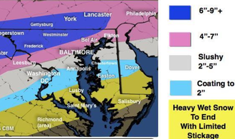
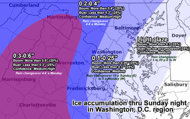
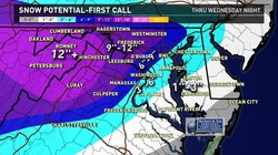
Impact on Monday
The snow is falling a lot harder than anticipated...Clarksburg has almost 5 inches on the ground!
The map on the left shows the anticipated ice totals that will accumulate by the end of tonight.
Things should change over to all rain between 4 and 8AM tomorrow morning, but we have so much on the ground right now, that we may still see issues well into the morning.
Official Prediction: 3 Pencils
The map on the left shows the anticipated ice totals that will accumulate by the end of tonight.
Things should change over to all rain between 4 and 8AM tomorrow morning, but we have so much on the ground right now, that we may still see issues well into the morning.
Official Prediction: 3 Pencils

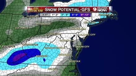
SUPER SLICK SUNDAY (12/8/13)
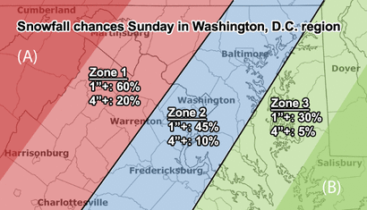
My buddies over at Capital Weather Gang created this image to show the chances of us getting over 1 inch of snow and over 4 inches of snow.
There is a good chance we will get a couple inches of snow prior to the sleet and fereezing rain, which could make Sunday a huge mess.
Unfortunately, that doesn't mean much for us...as temperatures are expected to climb to the mid 40's by late Sunday Night, changing everything over to rain. That means there is a good chance any snow and ice that is on the ground will be long gone by the Monday morning commute.
There's a small chance the temperatures stay colder a little longer than expected, which could possibly give us a delay, but right now I don't see that happening.
Early Prediction: 1.5 pencils, but we will round up to 2.

Winter Storm 11/26-11/27???
As you can see, we are right on the freezing rain/rain line. If things work out in our favor, we can have some freezing rain or sleet for the middle to late part of the morning commute. That could possibly lead to a delay, but I wouldn't hold your breath.
This storm may come in with a little frozen precipitation, but it will turn into a cold rain for the rest of Tuesday into Wednesday. It may leave as some freezing rain or sleet Wednesday afternoon, but I would not expect any delays or cancellations due to this storm for our area. With that being said, anytime there is even a chance of frozen precipitation, the pencil rating increases...
Official Prediction: 2 Pencils

November 12th, 2013: Slight Chance of Wet Snow
Happy Veterans Day everybody! Late tonight into tomorrow we will have some light rain with a drop in temperatures that may lead to a few wet snow flakes.
Unfortunately, this will not be enough to make MCPS bat an eye, so I do not expect any cancellation or delay.
Prediction: 1 Pencil

Winter 2013/14
Welcome back everybody! I know the recent cold weather has everyone thinking about the Winter, so let's throw some facts out there.
Last year (2012), two days of school were cancelled in October due to a Hurricane!
March 6th, 2013 was the last day of school that was cancelled due to winter weather.
Yesterday, October 24th 2013, we saw snow flurries in Germantown, MD!
In the next couple days we will start our contest for a $20 Chipotle Gift Card!
Winter Weather Advisory in Effect for Early Monday!
Let me start off by saying, that I am not confident in any forecast this late in the year. With that being said, the timing of this winter weather is PERFECT when it comes to causing a delay or closing.
We are only expected to have 1-2 inches of snow. That may or may not change to sleet in the mid-morning. Though the ground isn't warm, the snow/sleet may still cause some problems on the roads.
Prediction: 2 Pencils!
We are only expected to have 1-2 inches of snow. That may or may not change to sleet in the mid-morning. Though the ground isn't warm, the snow/sleet may still cause some problems on the roads.
Prediction: 2 Pencils!

Things Not Looking Good 8PM Update
I just drove a few miles in the Gaithersburg area and the roads are perfectly fine (other than being wet). Now, temperatures are still expected to drop below the freezing mark so there is still a slight chance for a delay. I wouldn't count on it...but you never know.
Prediction: 1 Pencil
Prediction: 1 Pencil

Thursday, 3/7/13 6PM Update
The major storm was a major disappointment. I live in Gaithersburg and I would say there is about 3 inches of snow on the ground (most forecasted between 7 and 14 inches for this area!).
Things can freeze over tonight and may cause some problems in the northern half of the county. There is a small chance school is cancelled, and I think we are about 50/50 for a 2 hour delay.
Prediction: 2 Pencils (closer to 2.5)
Things can freeze over tonight and may cause some problems in the northern half of the county. There is a small chance school is cancelled, and I think we are about 50/50 for a 2 hour delay.
Prediction: 2 Pencils (closer to 2.5)

Things Are Looking Good! Tuesday, 3/5/13 4PM
I am going to stick to my last prediction and go with anywhere between 6-9 inches for the southern part of the county, and 9-12 for the northern part. I cannot see us having school tomorrow (3/6/13).
Prediction: 5 Pencils!
Prediction: 5 Pencils!

The LION Known as March
It's looking like we will be getting anywhere between 6 inches to a foot of snow for Montgomery County!
If this goes down the way it is supposed to, this will be the biggest storm since 2010!
Things are looking good for Wednesday AND Thursday!
Prediction: 4 Pencils (and climbing)!
If this goes down the way it is supposed to, this will be the biggest storm since 2010!
Things are looking good for Wednesday AND Thursday!
Prediction: 4 Pencils (and climbing)!

Friday, February 1st
We are expected to go into February with a little bit of snow. Unfortunately, the last few days have been unseasonably warm, and we're not expected to get anything more than a dusting. The flurries will be starting overnight tonight and continue into the early morning. I dont see anything more than 1/10th of an inch. Sorry :/
Rating: 1 pencil (really this time)
Rating: 1 pencil (really this time)

Monday, January 28th
A winter weather advisory is now in effect for Monday morning starting at 5AM. That is perfect timing. We are expected to have only a little bit of ice and it should warm up fairly quickly, but the timing is ideal. I will be the first to admit that I have been wrong the last two days when it came to the 2 hour delay and early dismissal. To keep up the good luck, I will once again give tomorrow a low rating.
Rating: 1 pencil
Rating: 1 pencil

Friday, January 25th
Didn't mean to get your hopes up, but it looks like any snow that'll come will be int he afternoon. RIght now...I am not too confident that it will cause any delay, closing, or early dismissal.
Rating: 1 Pencil
Rating: 1 Pencil
Thursday, January 24th
UPDATE 1/24 3:00AM
THe snow has decided to actually fall. It's cold enough for it to stick, and even though it's the kind of snow you can sweep away, I think it'll be enough to cause a delay!
Rating: 2 Pencils
THe snow has decided to actually fall. It's cold enough for it to stick, and even though it's the kind of snow you can sweep away, I think it'll be enough to cause a delay!
Rating: 2 Pencils

Snow Coming???
The next few days will be FREEZING. It will feel like it's in the single digits for the next 24 hours and won't get much better until Friday.
This Friday, January 25th, we may get our first real shot at snow. Some models say we can get 4-6 inches, while others show the weather starting as snow/wintry mix before changing to rain.
The timeline is tricky...i've seen Friday morning and i've seen Friday afternoon. If we get the storm on Friday morning...we may be in for our first delay of the year. If not, we will just be annoyed going into the weekend.
Keep checking in!
Thursday, January 17th, 2013
We have a little unexpected burst of snow coming our way tomorrow.
If the cold air makes it in here like it's supposed to, a lot of this rain will turn to snow.
How much will we get? Well the picture CBS has posted says our region will get between 1-3 inches. Unfortunately, the time the snow is supposed to hit is not a good for those of us looking for a school closing or delay.
The snow will probably start Thursday afternoon, and end by Thursday night. While there may be some slick spots, i don't expect it to have much of an impact on Thursday's afternoon commute or Friday's morning commute.
Rating: 1 pencil

Tuesday, November 27th.
Let me start off by telling you that I get extremely excited when I open my Accuweather app and see little snowflakes on a certain date. On Saturday, that's exactly what happened.
I don't want to get anyone too excited, because I don't think this will be anything major, but we may see some flakes during the morning commute. It's supposed to start overnight, around 4AM and continue until the late morning hours before turning completely into rain.
Unfortunately, the ground will not be cold enough for the snow to stick on the street, but as of now...I see this as a cold rainstorm.
Rating: 1 Pencil

Winter Storm Athena
The first winter storm of the season is coming through the northeast, and the Weather Channel has taken it upon themselves to name her Athena. The National Weather Service was asked if the name would be made official, but they replied by saying that they will not be naming winter storms.
This winter storm brings the first threat of snow to our area, but it is not anything to get excited about. I have seen reports of 1-3 inches slightly north of here, but I don't see us getting anywhere close to that. It may snow a bit, and it may stick on the grassy areas (not cold enough for the streets), but we will not get anything that will cause any delays or closings.
Rating: 1 pencil.

Hurricane Sandy RECAP 10/31/2012 10:30AM
When it comes to Montgomery County, Sandy wasn't really much worse than a big rainstorm with high winds. I lost power for about 10 minutes total (MoCoSnow headquarters is currently in the Kentlands)...and that's not too bad. I know there are other places in the county that had it a little worse than I did, but for the most part, Sandy was the perfect storm...for me.
I think one of the worst things that can happen is losing power. Everything I think of doing requires power. Being able to sit at home for 2 days and still do whatever I wanted was the best. Of course, worrying about losing power wasn't that good, but it is what it is!
I think one of the worst things that can happen is losing power. Everything I think of doing requires power. Being able to sit at home for 2 days and still do whatever I wanted was the best. Of course, worrying about losing power wasn't that good, but it is what it is!
MCPS Schools will be OPEN ON TIME on Wednesday, October 31st 10/30 11:00AM
The storm wasn't as bad as anticipated, but we still got TWO days off! That's two days better than all of last year and we're still in OCTOBER! Keep on doing those snow dances...MUCH more to come.
MCPS SCHOOLS WILL BE CLOSED on Monday and Tuesday October 29th and 30th!
I would expect schools to be closed on Wednesday as well if things are as bad as predicted. More to come...
GREAT News...Howard County announces schools will be CLOSED on Monday Sunday, October 28th 12:35 PM
Our neighbor, Howard County, has announced that schools will be closed tomorrow, Monday 10/29. This is wonderful news because Howard County is probably the county that is most comparable to us. Last year, Howard County did have a day off, and we didn't even have a delay...so this doesn't necessarily mean we will be off as well.
The storm looks like it is tracking a little further north than previously expected, but nothing has changed in regards to our forecast. In fact, i've seen a lot of places calling for 5-10 inches of rain still, but I think we will be in the 3-7 range.
New prediction (remember, I don't think we will have a delay...more likely to get an early dismissal):

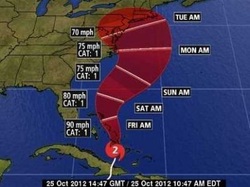
Update on Hurricane Sandy Sunday, October 28th 10:15 AM
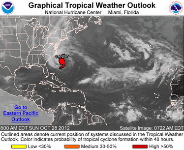
Sandy is now making her way up the coast and her path is projected to take her just above MoCo and up the coast.
We will have some rain today (heavy at night), but it will not come close to the heavy rain and high wind that are coming throughout the day Monday and into Tuesday.
Tomorrow morning, we will have sustained winds (consistent) of 15-25 mph with gusts over 30mph. As the day progresses, winds will be sustained at 35-40mph with gusts up to 60mph. Winds may even increase as the night goes on (up to 65mph), and we can end up with 2-4 inches of rain by the end of the night.
On Tuesday, we will continue to deal with high winds and can get an additional 1-3 inches of rain. Rain totals will be between 3-7 inches.
I believe power outages will be our biggest issue, and they can close schools just as easily as winter weather. For Monday, we have a better chance at no school or an early dismissal than we do a two-hour delay.
EMERGENCY MESSAGE: 10/26/2012 at 5:20 PM -- Montgomery County Public Schools continues to monitor the path of Hurricane Sandy and its potential impact on school operations. A decision about school operations for Monday, October 29 will be made no later than 5 a.m. on Monday and announced through emergency communication methods.
Add one pencil to my Tuesday prediction, but my prediction for Monday is.....

Frankenstorm to Hit on Sunday Evening
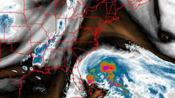
Hurricane Sandy is on her way up. She will join forces with the cold front from Canada (eh?) to bring a LOT of rain to the area. Usually, hurricanes lose a lot of their strength before they make it to our area, but in this case, Sandy may arrive while still being a category 1 hurricane.
We may have sustained wind gusts (consistent wind) of 80 mph! We will also have around 5-8 inches of rain. When it comes to a rain to snow conversion, there is not an exact number to go by, but it is between 5-10 inches of snow for every inch of rain. That means anywhere from 25-80 inches of snow if it was cold enough! That is almost 7 feet of snow! Unfortunately, it will not be cold enough for us to get snow...and if we do get any, it will not be cold enough to stick. We may have to deal with power outages though, and those are the worst. The only good thing that can come from power outages is the possibility of school closures. Most of the time, these are on a school by school basis, but if enough of the county is out of power...the whole county may remain closed.
Upgraded rating: 2 pencils for Monday.

Frankenstorm! 10/25/2012 6:00PM
So basically, a Hurricane is coming from the south, winter weather is coming from the west, and cold weather is coming from Canada. They're all going to join forces to become one big storm, but the question is...where?
This storm has the ability to affect us from late Sunday through Thursday. If it tracks a bit to the east (closer to us), we will definitely get heavy rain and a lot of wind. If it tracks to the west (into the Atlantic Ocean), we may not get anything at all. If the weather is cold enough there can be plenty of snow mixed in...and usually, if our first dose of winter weather is bad, it gives us something to look forward to.
There are a lot of factors that will play into how this storm comes together, and right now, I just don't think it will be cold enough for us to get any significant winter weather. As long as there is a chance, I will be here to let you know.
So far, this storm is rated one pencil. Check back over the weekend for more updates.

Last Winter Failed Miserably 10/24/2012 10:00AM

The bad bews is...
After the 2010/11 school year gave us 11 days with a school closing or delay,
2011/12 kept us in school the ENTIRE winter. We didn't even have a 2-hour
delay...and if you ask me, a 2-hour delay is pretty much a half day, which is
pretty much the easiest thing ever.
I can't remember one winter that didn't give us a delay, early dismissal, or a day off of school. Unfortunately, it happened, and we have to move on.
The good news is...
Almost every meterologist and their mother is predicting a crazyyyy winter when it comes to wintry weather. Now that doesn't guarantee that we will actually get this type of weather, but it does give us hope. A couple things have to go our way, and we have to hope that the snow/ice doesn't come on a weekend (Friday night snowstorms are the WORST), but I can almost guarantee you that we will have more time off of school than we had in the previous year.
So...do a snow dance, wear your pajamas inside out EVERY single night ever, or pray to whoever it is you believe in. We want some snow this year.
